
CSA Ocean Sciences Inc. (CSA), a global marine environmental consultancy, has enhanced its disaster response capabilities with the addition of the WingtraOne GEN II unmanned aerial vehicle (UAV) to its uncrewed systems fleet.
Designed for rapid post-disaster assessments, the new UAV complements CSA’s existing suite of uncrewed surface vehicles (USVs), enabling the firm to efficiently evaluate storm-impacted infrastructure across inland, coastal, and offshore locations.
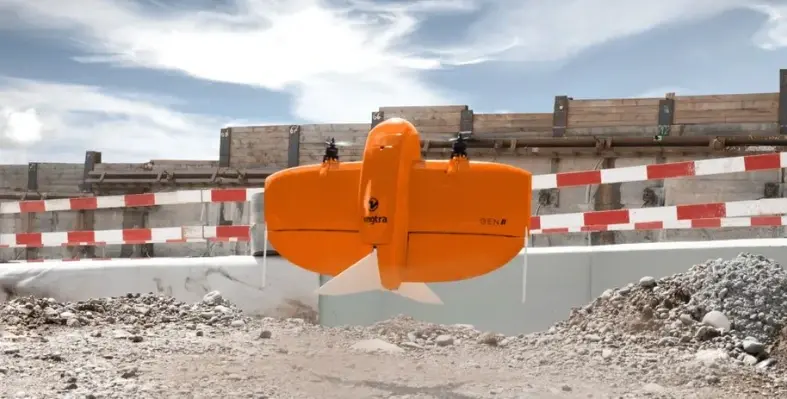
The WingtraOne GEN II features vertical take-off and landing (VTOL), allowing it to operate in confined or debris-covered areas. Capable of surveying up to 310 hectares in under 50 minutes, the UAV significantly accelerates damage assessment timelines. With an IP54 rating and resilience in sustained winds up to 27 mph, the platform supports various payloads, including RGB, LiDAR, and multispectral sensors, tailored to the assessment’s scope.
This airborne capability complements CSA’s SeaRobotics-built USV fleet, which includes 1.8-m to 11.0-m vessels equipped with modular sensor arrays for hydrographic mapping, submerged debris detection, and waterway navigability assessment, especially in conditions hazardous to crewed operations.
In anticipation of heightened tropical activity in the Atlantic Basin, CSA is actively coordinating with FEMA, state emergency agencies, utility providers, and insurers to prepare for rapid response. Its Crisis Management Team offers a 24/7 hotline for clients and partners, enabling immediate incident registration and deployment of tailored response teams.
“In the critical hours following hurricanes, floods, and other natural disasters, rapid situational awareness is essential,” said Chris Echols, CSA’s vice president of commercial operations and Geomatics Lead. “By deploying autonomous craft rather than personnel in potentially hazardous environments, we can safely and efficiently deliver precise images and data from above, on, and below the water that allow response teams to prioritise the most appropriate action plan. Our latest acquisition, the WingtraOne GEN II UAV, brings a new dynamic to our time-sensitive surveying capabilities, delivering high-resolution aerial maps, 3D models, and orthomosaics with ultra-precise accuracy—as tight as 1 cm with Post-Processed Kinematic (PKK).”
“Our mission is simple: to deliver clarity, speed, and safety when it matters most,” added Echols. “By integrating surface and subsurface data, CSA is now able to deliver an unparalleled understanding of the post-disaster landscape, enhancing decision-making for emergency managers, FEMA units, insurers, and infrastructure providers, all while keeping personnel out of harm’s way in often dangerous and unpredictable environments.
“All CSA’s disaster response technologies are engineered to minimise risk to personnel while accelerating the delivery of actionable insights. Whether scanning rooftops for insurance assessments, identifying structural collapse, or guaranteeing safe maritime navigation, CSA’s disaster response service is designed to optimise survey time, streamline overheads, and increase operational confidence.”